halo
|
up patrick baudisch |
| halo try it out (flash)! video WMV (24M) publications poster at UIST'04 |
|
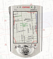
This halo-enhanced map shows five arcs, each indicating the location of one restaurant located off-screen (this figure uses a translucent overlay to show the actual locations of the restaurants). The higher curvature of the arc at the bottom right allows users to conclude that this restaurant is closer than the others. |
As users pan and zoom, display content can disappear into off-screen space, particularly on small-screen devices. The clipping of locations, such as relevant places on a map, can make spatial cognition tasks harder. Halo is a visualization technique that supports spatial cognition by showing users the location of off-screen objects. Halo accomplishes this by surrounding off-screen objects with rings that are just large enough to reach into the border region of the display window. From the portion of the ring that is visible on-screen, users can infer the off-screen location of the object at the center of the ring. We have conducted a user study comparing Halo with an arrow-based visualization technique with respect to four types of map-based route planning tasks. When using the Halo interface, users completed tasks 16-33% faster, while there were no significant differences in error rate for three out of four tasks in our study.
|
Get the
Flash Player to see this player.
|